Use PhotoGPS with Aperture
May 16, 2014
Are you a frequent image shooter?
If you have an iPhone, it’s easy to know where you have taken a picture, and once they’re imported in Aperture, you can use the Maps to find pictures based on a location.
But what if you don’t exclusively use your iPhone ?
For example, I have a DSLR old Canon, with a great lens (50mm from Canon, yes the plastic one), and a better, but heavier great lens (30mm f/1.2). And I also have a simple and useful Panasonic GH1.
The pictures taken with these cameras are by default not geotagged, no position in their metadata. And doing it by hand is … a pain.
The solution is to use PhotoGPS, a small and simple app I made that allows you to record your position ALL THE TIME without killing your battery and export that info.
With PhotoGPS, you just launch the app once, and it will always record where you’ve been, based on your cell network towers and wifi networks. If you want a better position, you launch it again and it will use GPS to know where you are, with up to 9 m precision.
You can then review and export your positions based on the date.
Once you want to geotag pictures in Aperture, export the data from your iPhone by selecting the dates you’re interested in. You’ll get them by email in a .gpx file attached yo your email.
In Aperture, first select the project you want to work one.
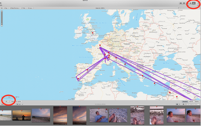
Then select the places in the upper RIGHT corner (it’a a globe icon)

Just under the map, on the lef side, you’ll find a button called “GPS”

Import the file you got by mail, and you’ll get the lines describing your course. Then select an image taken at a precise location, drag it on the precise location on the line, and Aperture will ask if it needs to locate all pictures based on the time etc.
Et Voilà !